September 2016, Weekdays-weekend, 3-nights, Whittleton campsite A029
 |
| View of Lookout Point from Natural Bridge |
Advance reservations, arrival and check-in
When I looked at the campgrounds online in
Natural Bridge State Resort Park, I thought we would want to stay in
Middle Fork Campground along the stream. By the time we were ready to make our reservation, all of those sites were either reserved or not suitable, so we reserved a site in
Whittleton Campground.
 |
| Labeled map |
We arrived via Highway 11 from the south. The Whittleton campground sign is a short, small sign at the entrance with no forewarning, and we missed it. We pulled into the next drive north of Whittleton, which was the entrance to the skylift and lodge. We turned around after driving over the entrance bridge because the sign clearly said "No RVs" to the left. We could have also turned around by the skylift, if we had turned right. Even though the map shows a road through the picnic area after turning left, you cannot get through on that road with an RV. There is also a drive into Whittleton campground on the south side of the stream, which is a dead end with no turn around. If you happen to miss the main drive arriving from the north with an RV, I do not suggest pulling into that drive. You can enlarge the labeled map I have inserted here by clicking on it.
During our stay, we met someone who told us he had also missed his campground sign. He said he turned into the same drive we did, but then he turned left and continued to the lodge where he could not turn around. He told us they called a ranger to turn his RV around for him, and that the ranger told him this happens frequently.
The campground office was not staffed when we entered Whittleton campground on Wednesday afternoon. Our site had a reserved tag with our name on it.
Whittleton campsite A-29
The website says that all of the Whittleton RV sites at the end (A024 - A037) are about the same size; however, there is more room to maneuver into the higher numbered sites at the very end, as the road is a bit wider there. Be aware that all of the sites in both campgrounds require some finesse to get an RV into. We got our 5th wheel on our site without any trouble; however, we observed or talked with others who had difficulty. The road in front of site A-29 is quite narrow, and there is a ditch across the road right before a steep hill - so, there is no room to drive/maneuver across from the site.
 |
| Whittleton campsite A-29 |
This campsite is mostly level; the back is a bit lower than the front, and we had to put one block under the tires on the driver's side. A brook runs through behind the fire pit. We could hear the brook, although it was not visible when sitting down at the fire pit. There is a good view of the brook from site A-28.
Site A-29 has water and electricity; however, the water spigot was so far away we did not have enough hose to keep it hooked up. There was a problem with the power outlet for sites A-29 and A-30. There was not anyone on site A-30 during our stay, so we tried both outlets. Our power flickered several times overnight (when nothing was running), so we plugged into the other outlet the next day. Within a few hours, the power started flickering again. We never ran our A/C or anything that would cause this to happen. In fact, the power flickered at times when we were not using any juice. We reset everything in the 5th wheel and checked the power box each time this happened. The office was not staffed until Friday, so we told someone about the problem at that time. The person I spoke with called maintenance and said someone would come and check it. I do not know if someone came to look at things when we were out hiking that day. We did not have any more trouble the rest of our stay after this.
Facilities: showers, restrooms, dump station
Showers,
flush toilets, coin operated
laundry machines, and the
dump station are located in the tenting area of Whittleton campground. The turn from the RV road to the road that crosses the brook to this area is quite sharp, and we would not have been able to make the turn when leaving our campsite. We considered turning around by the ranger station to enter from the opposite direction, and then changed our minds. In addition to the narrow roads in this park, there were several low branches in the tenting area that we would have hit with the top of our 5th wheel. Fortunately, we had emptied our tank when we left
Dale Hollow State Park, and we were able to fill our fresh water tank on our campsite. Although we did not have enough hose to keep the water hooked up during our stay, we had enough to reach the tank for filling purposes. The website says this campsite is only 18' wide, which cannot be correct. We were parked on our site pad, and the water and power hookups between sites A-29 and A-30 were more than 30' away from the opposite side of our 5th wheel. The water spigot was farther away than the power source; we could barely reach to fill our tank using both our 25' water hoses.
We checked the dump station in Middle Fork campground, and decided we did not want to use that one either. The drive into Middle Fork campground is steep, and the dump station is located on this incline. We knew the tank would not empty well, or completely, while parked on a hill.
Recreation: hiking, skylift, natural bridge, and more
There are many fabulous
hiking trails in Natural Bridge State Resort Park. We hiked both trails that start in Whittleton campground, along with several across the road to Natural Bridge, Lookout Point, Lovers Leap, Balanced Rock, the cave, and Woodland Center. Pets are not allowed on any of the hiking trails in this state park, even the ones in the campground. Pets are allowed in the campground; just not on the trails. The signs in this park did not warn of snakes, like the signs in
Mammoth Cave area. The warning signs in this park alerted hikers to be aware of bears. We did not see any wildlife, except a non-poisonous snake when hiking Whittleton Branch.
 |
| Whittleton Branch |
Both trails from the campground were easy ones.
Henson Arch was short with a slight incline.
Whittleton Branch was not difficult, although the trail was longer than I had expected. The sign said this trail is two miles roundtrip, and it was 2½ miles roundtrip. Not much difference, although the trail seemed less traveled before we got to the end, and I had begun to think we had missed a turn or something. The rocks along this trail and at the end were massive. You can find more information and photos for this park in the
Natural Bridge State Resort Park Facebook album.
 |
| Whittleton Branch - that tiny figure is my husband looking up! |
If you want to hike a roundtrip loop to
Natural Bridge, I suggest going up either
Original Trail or
Battleship Rock trail, and returning on
Balanced Rock trail. Battleship Rock and Original Trail take you to the bottom of the arch. You then need to walk through a narrow path up steps to the top of Natural Bridge. There is a photo of this narrow passage in the Facebook album. Balanced Rock trail, which is the steepest of these three trails, returns from the top of Natural Bridge.
 |
| Stone steps near the start of the trail from the gift shop and parking lot |
We did not see anyone on Battleship Rock trail in the morning, and we only passed two sets of hikers on Balanced Rock trail on our return. We hiked Battleship Rock again the next day, on our way back from Needle's Eye, and we did not see anyone on the trail that day either. Most visitors either went up and down Original Trail to Natural Bridge, or they took the Skylift from the northern parking lot to the top.
 |
| Under the arch where Original Trail ends |
The trail between
Lookout Point and
Lovers Leap is on the edge and it is not very wide. There were no railings along the trail, so we decided we did not want to hike this trail. Instead, we hiked to Lovers Leap the next day - up
Devil's Gulch and down
Needle's Eye! Both of these trails were very scary, and I am not sure this was any better than if we had hiked the narrow trail along the top edge. We did not meet anyone who had hiked either of these two trails, and we did not see anyone on our way to Lovers Leap or on the way back. Portions of both trails were rock steps with no railing or anything to hang on to. When we descended Needle's Eye, there were so many leaves and dirt on the stones, it did not look like anyone had been on the trail recently.
 |
| Devil's Gultch |
 |
| Devil's Gultch |
 |
| Needle's Eye |
A room in
Woodland Center with nature displays was open during our visit, although the gift shop was not. The
gift shop in the north parking lot by the
Skylift was open, and the prices were reasonable. The gift shop in the lodge was also open, although we did not find much of interest in that shop.
Middle Fork campsites, wireless, firewood, misc.
If you are considering a campsite in
Middle Fork campground with an RV, be aware that the road into this area is quite steep; both the main entrance road, and the second drive into sites B027 - B035. Before we visited, it was difficult to visualize the campsites, even with the photos. One site we had considered was B036, because it looked like a large private site. This site has trees around it; however, it is on the entrance road. In addition to the traffic from the road, you would need to back up the hill into the campsite. A nice feature of Middle Fork campground, is that you can ride bikes on the paved road from the campground to the gift shop/parking area without having to cross Highway 11.
The state website and our reservation said that
wireless Internet was available for purchase; however, we did not have a signal in Whittleton campground. I did not check other areas of the park to see if a signal was available elsewhere. Cell service was not available when hiking in some areas. I received a blank text while hiking one day.
 |
| Wood purchased in park for $11.50 |
 |
| Wild Things where we found firewood the next day! |
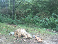
Firewood in the park was expensive, and we had a difficult time finding a ranger to purchase wood. We tracked someone down our second night and purchased two bundles of wood (10 pieces) for $11.50. The next day, we discovered a store called Wild Things just north of Whittleton campground. The cost was $4 for 8 pieces of wood, and we got to pick our own pieces.
Next time we visit this area, we plan to stay in Red River Gorge at Koomer Ridge Campground, so we can hike the other side of KY-15. We did not pick that campground for our first visit to the area because sites in Koomer Ridge Campground are first come, first serve - no reservations accepted. The online information says there are 19 RV camp sites, and 15 of them can take an RV up to 35'.
Let me know if you have any questions, and feel free to share this post for others!


No comments:
Post a Comment